
Geology and Geophysics
GATE GG-1 topic:geomorphology PYQs
Build your understanding with focused practice from past exam papers.
How to practice topic:geomorphology
Attempt a question, record the concept and assumptions, then check the available answer. Rework mistakes after revising the relevant concepts. Topic tags can overlap; review the question context.
Questions 1–10 of 19. Imported answers require independent review unless marked reviewed.
Question 53
Open questionGGMCQ2 marksNeeds review
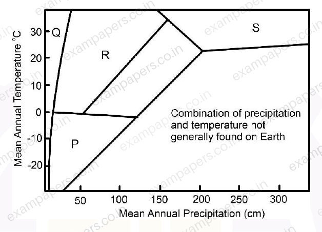
Choose the marked climate zones P, Q, R and S in the figure CORRECTLY from the following options.
Your answerChoose one option.
Log in to check the answer
You can attempt this question now. Sign in to view the answer key, explanations and discussion.Log in to check answerQuestion 16
Open questionGGNAT1 markNeeds review
A watershed has an area of 74 km
. The stream network within this watershed consists of three different stream orders. The stream lengths in each order are as follows:I
order streams: 3 km, 2.5 km, 4 km, 3 km, 2 km, 5 kmII
order streams: 10 km, 15 km, 7 kmIII
order streams: 30 kmThe drainage density of the watershed is __________ km/km
(Round off to two decimal places)
Log in to check the answer
You can attempt this question now. Sign in to view the answer key, explanations and discussion.Log in to check answerQuestion 36
Open questionGGMCQ1 markNeeds review
In which one of the following rivers does helical flow play an important role in controlling river dynamics and channel morphology?
Your answerChoose one option.
Log in to check the answer
You can attempt this question now. Sign in to view the answer key, explanations and discussion.Log in to check answerQuestion 43
Open questionGGNAT1 markNeeds review
The sediment yield at the outlet of a river having a catchment area of 8 km
is 6000 tons/year. If the sediment density is 1.5 g/cm
, the average erosion rate of the river basin is __________ mm/yr.(Round off to two decimal places)
Log in to check the answer
You can attempt this question now. Sign in to view the answer key, explanations and discussion.Log in to check answerQuestion 56
Open questionGGMSQ2 marksNeeds review
Which of the following options is/are correct for movement of warm-base glaciers?
Your answerSelect all correct options. You can choose more than one.
Log in to check the answer
You can attempt this question now. Sign in to view the answer key, explanations and discussion.Log in to check answerQuestion 41
Open questionGGMSQ1 markNeeds review
Which of the following statements is/are CORRECT?
Your answerSelect all correct options. You can choose more than one.
Log in to check the answer
You can attempt this question now. Sign in to view the answer key, explanations and discussion.Log in to check answerQuestion 44
Open questionGGNAT1 markNeeds review
The areas of drainage basins A and B are 25 km² and 50 km², respectively. The total length of drainages of all orders in basin A is 20 km. If both the basins have the same drainage density, the total length of drainages of all orders in basin B in km is __________ (in integer).
Log in to check the answer
You can attempt this question now. Sign in to view the answer key, explanations and discussion.Log in to check answerQuestion 60
Open questionGGNAT2 marksNeeds review
In a drainage basin, the number of the 1ˢᵗ, 2ⁿᵈ, 3ʳᵈ, 4ᵗʰ and 5ᵗʰ order streams are 240, 40, 8, 2 and 1, respectively. The average of all calculated bifurcation ratios is __________. [round off to 2 decimal places]
Log in to check the answer
You can attempt this question now. Sign in to view the answer key, explanations and discussion.Log in to check answerQuestion 12
Open questionGGMCQ1 markNeeds review
Which one among the following coastal erosional landforms is caused by the action of sea waves?
Your answerChoose one option.
Log in to check the answer
You can attempt this question now. Sign in to view the answer key, explanations and discussion.Log in to check answerQuestion 45
Open questionGGMCQ2 marksNeeds review
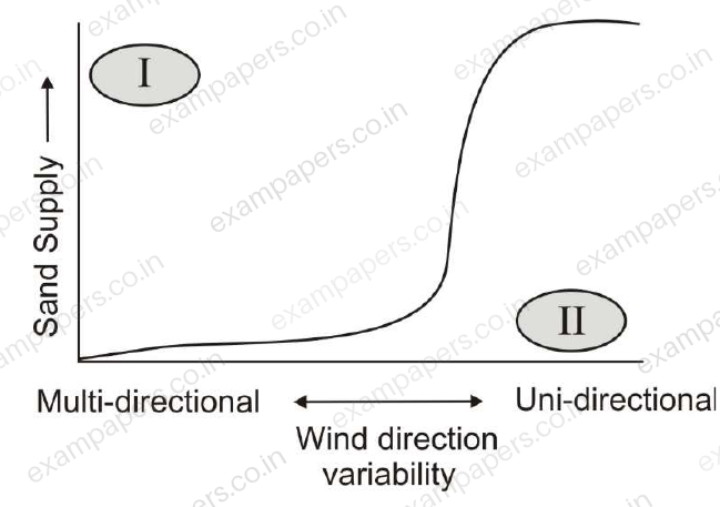
The sand supply and the variability of wind direction results in different dune types. In the options below, choose the CORRECT pair of dune types marked I and II in the figure.
Your answerChoose one option.
Log in to check the answer
You can attempt this question now. Sign in to view the answer key, explanations and discussion.Log in to check answer