
Mining Engineering
GATE MN Mine Surveying PYQs
Build your understanding with focused practice from past exam papers.
Questions 11–20 of 38. Imported answers require independent review unless marked reviewed.
Question 48
Open questionMNNAT2 marksNeeds review
In a tacheometry survey, the readings observed are given.
Instrument Station | Staff Station | Bearing of line of sight | Vertical angle | Staff readings (m) |
|---|---|---|---|---|
P | A | 145° | +8° | 1.2, 1.7, 2.2 |
P | B | 205° | +3° | 0.8, 1.2, 1.6 |
The additive and multiplying constants of the instrument are 0 and 100, respectively. The length of the line AB in m, is _____. (round off up to 2 decimals)
Log in to check the answer
You can attempt this question now. Sign in to view the answer key, explanations and discussion.Log in to check answerQuestion 24
Open questionMNMCQ1 markNeeds review
Match the following items with their respective contours
Item | Contour |
|---|---|
(P) Isopachs | (1) slope |
(Q) Isotherms | (2) thickness |
(R) Isocline | (3) temperature |
Your answerChoose one option.
Log in to check the answer
You can attempt this question now. Sign in to view the answer key, explanations and discussion.Log in to check answerQuestion 25
Open questionMNMCQ1 markNeeds review
In an astronomical survey at a given station, the pole star is located at an angle of 27° from the horizon. The latitude of the survey station in degrees is
Your answerChoose one option.
Log in to check the answer
You can attempt this question now. Sign in to view the answer key, explanations and discussion.Log in to check answerQuestion 26
Open questionMNMCQ1 markNeeds review
The position tracking of a point by GPS is based on the technique of
Your answerChoose one option.
Log in to check the answer
You can attempt this question now. Sign in to view the answer key, explanations and discussion.Log in to check answerQuestion 38
Open questionMNMCQ2 marksNeeds review
Match the following devices with their intended applications.
Device | Application |
|---|---|
(P) Ground Penetrating Radar | (1) Spatial positioning of a point |
(Q) Tactile Sensor | (2) Measurement of a borehole deviation |
(R) Global Navigation Satellite System | (3) Robotic Arm |
(S) Digital Inclinometer | (4) Locating subsurface features |
Your answerChoose one option.
Log in to check the answer
You can attempt this question now. Sign in to view the answer key, explanations and discussion.Log in to check answerQuestion 44
Open questionMNNAT2 marksNeeds review
Coordinate of two points A and B are (E 0 m, N 200 m) and (E 300 m, N 200 m), respectively. The bearing of two lines AO and BO are 67° and 35°, respectively. The easting of the point O, in m, is _____.
[rounded off to 2 decimal places]
Log in to check the answer
You can attempt this question now. Sign in to view the answer key, explanations and discussion.Log in to check answerQuestion 31
Open questionMNNAT1 markNeeds review
In a leveling survey, a reading is taken as 2.25 m. However, along the line of sight there is deflection of 20 cm with respect to vertical position of the staff. The correct reading, in m is ______. (round off to two decimal places)
Log in to check the answer
You can attempt this question now. Sign in to view the answer key, explanations and discussion.Log in to check answerQuestion 46
Open questionMNNAT2 marksNeeds review
The shaft-top coordinates of two vertical shafts are given below. The depth of the shaft A and B are 200 m and 149 m, respectively.
Shaft | Latitude (m) | Departure (m) | Surface RL (m) |
|---|---|---|---|
A | N70.0 | W150.0 | 250 |
B | N170.0 | E50.0 | 209 |
The downward gradient of the line joining the bottom of the two shafts in degrees, is ______. (round off to two decimal places)
Log in to check the answer
You can attempt this question now. Sign in to view the answer key, explanations and discussion.Log in to check answerQuestion 10
Open questionMNMCQ1 markNeeds review
In photogrametry, the ‘Tilt of a photograph’ refers to the angle between the
Your answerChoose one option.
Log in to check the answer
You can attempt this question now. Sign in to view the answer key, explanations and discussion.Log in to check answerQuestion 28
Open questionMNMCQ2 marksNeeds review
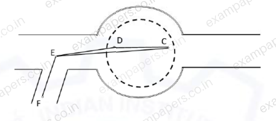
The pit bottom in a correlation survey is shown in the figure. Points C and D represent two suspended wires. The bearing of line CD is 286°00′00″ and its length is 4.64 m. The angle CED is measured as 00°00′40″. The length of line DE is 5.46 m. Considering the Weisbach triangle method, the bearing of the line CE is
Your answerChoose one option.
Log in to check the answer
You can attempt this question now. Sign in to view the answer key, explanations and discussion.Log in to check answer